UNO to Old River:A Guide to the Areaby Dale H. EasleyDepartment of Natural and Applied Sciences University of Dubuque In Cooperation with the New Orleans Geological Society |
Contents
Figures
1 Introduction
From the campus of the University of New Orleans to the Old River Control Structure is a stretch of South Louisiana of major historical and economic importance. The Mississippi River dominates (Fig. 1). It built the land, deposited the sediments and organic debris for oil and gas reservoirs, and today provides transportation, water resources, and a disposal site for wastes. The Mississippi rates among the world's leaders in
- volume of water and area of land drained (3,250,000 km2),
- volume of goods shipped through the Port of New Orleans (1st by a lot in the U.S. in tonnage, which is mainly grain and petrochemicals),
- concentration of petrochemical plants along the River between Baton Rouge and New Orleans (110 plants),
- productivity of wetlands (40% of the tidal wetlands in the contiguous U.S., and first among states in fish caught), and
- property damage due to floods (1st among U.S. states).
Human history along the Mississippi River is a story of balancing the threats with the opportunities, of reducing risks and enhancing commerce. Before pursuing that story, let's see how the Mississippi began.
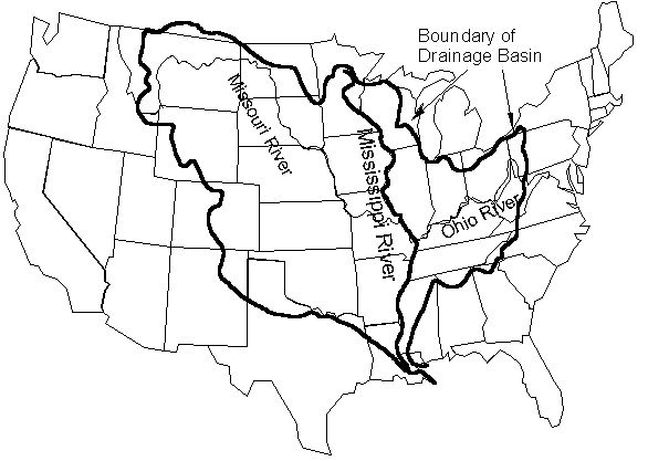
Figure 1: The Mississippi River drainage basin.
1.1 Mississippi River Structural Trough
The structural controls for the Mississippi River were created when the continents split apart in the Triassic, 245 to 208 million years ago. Small rifts were formed, radiating out from the main rifts separating the continents. One of these rifts became the Mississippi River Structural Trough. As the continents moved apart, the Gulf of Mexico widened and became a repository for sediment. From Cairo, IL, to the present mouth of the Mississippi, the land has been constructed, with a sediment pile 40,000 feet thick at the Gulf Coast. From Jurassic times to the present, layer upon layer of sediment has built the land, forming a series of layers dipping toward the Gulf.
During Pleistocene times, starting 2 million years ago, the formation of continental ice sheets led to the lowering of sea level, as much as 450 feet. During interglacial periods, sea level would again rise. This fall and rise in sea level led to the outward growth of the Mississippi delta into the Gulf and then its submergence, yielding alternating coarse and fine sediment. The last glacial period ended about 10,000 years ago. Since that time the Mississippi has continued to build into the Gulf by switching course like an unattended fire hose.
1.2 Deltas and Oxbows
As a stream builds a delta into a body of standing water (its base level), it lengthens its course and in the process flattens its gradient. The ability of the stream to transport sediment is decreased, and it begins to choke off its channel. The stream is then ripe for switching course, if it can find a shorter route to its base level. The Mississippi has repeatedly switched routes since the Pleistocene. It is now building its fifth delta since 2600 b.c.
Similarly, when a meander loop in a stream grows, the gradient also flattens. The efficiency of the stream in transporting sediment decreases. By cutting across the neck of the meander, a steeper route is developed. The meander loop no longer in use may form an oxbow lake, such as at False River, LA, which we will drive by today (Fig. 2).
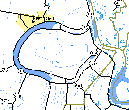
Figure 2: False River, LA, a meander cutoff of the Mississippi River.
2 New Orleans and the Mississippi River
2.1 History
The first French explorers recognized that controlling the Mississippi River was a key to controlling the interior of the continent and their colony in the New World. In addition, by sailing through Lake Pontchartrain and Bayou St. John, ships could avoid fighting the River's current, cutting the passage time from the Gulf from 30 to two days. When the French arrived, Native Americans had established a trading post on the natural levee of the Mississippi where it met the portage route from Bayou St. John. On the high ground of the levee, about 14 feet above sea level, New Orleans was established in 1718. Away from the natural levees of the Mississippi the land sloped away to marshes and swamps (Fig. 3). The only other relatively high ground was along the levees of distributary channels---Bayou Metairie, Bayou Savauge, and Bayou St. John. Metairie and Gentilly Ridges were about four feet above sea level.
In 1762, France ceded Louisiana to the Spanish, but regained it in 1800. Napoleon had hopes of a French empire in the New World. However, the loss of Haiti to a slave rebellion and the failure to retake it in 1802 led Napoleon to sell Louisiana to the United States in 1803.
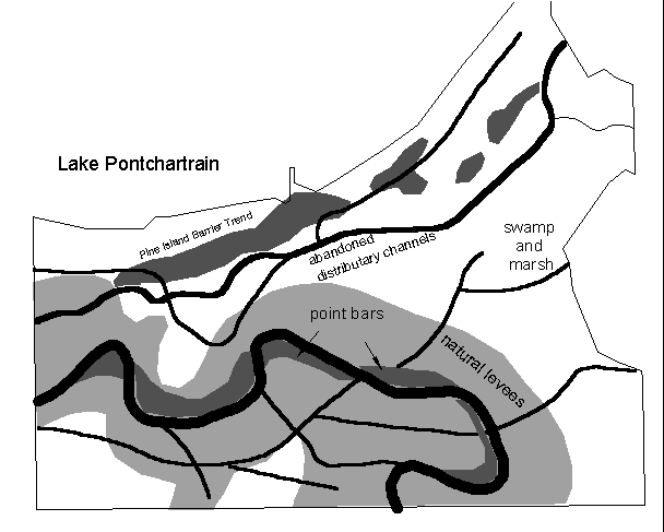
Figure 3: Map of natural levees, swamps, marshes, and other landforms in the New Orleans area, circa 1750
(after Snowden et al., 1980).
2.2 Canals and Levees
As the population of New Orleans grew, pressure for more land for settlement increased, leading to draining of swamps and marshes. In addition, levees were constructed to protect the population from the periodic flooding of the Mississippi. As the land was drained, it subsided, increasing the chance of flooding. Gradually the entire city was ringed with levees and drainage canals were constructed into which rainwater is pumped. The London Canal next to UNO's campus is one of these canals.The land where UNO's campus is located was marsh and swampland at the time of New Orleans establishment. In 1924 a project was commissioned to build a seawall, pump sediment from the lake bottom into it, and create 2,000 acres of land (Widmer, 1993). On part of this land was constructed a Naval air base that saw action during World War II. On the site of the Naval air base was constructed UNO. The first students at UNO attended classes in the old military buildings.
2.3 Bonnet Carre Spillway
Upriver from New Orleans are a multitude of structures aimed at preventing flooding. Besides the levees, the first we will drive over is the Bonnet Carre Spillway (Fig. 4). The Bonnet Carre Spillway allows flow from the Mississippi River to bypass New Orleans through Lake Pontchartrain. Previous to the recent opening, it was last opened in 1983.
The Bonnet Carre Spillway was constructed in 1932, partly in response to the disastrous 1927 flood that covered 26,000 square miles. The Spillway is one of several diversion projects, including the Morganza Floodway, that allow flow to bypass New Orleans. The Bonnet Carre connects the Mississippi with Lake Pontchartrain above New Orleans. Before the recent opening, it was last opened in 1983. Environmentalists are concerned about the effects of its opening because of pollution in the Mississippi, differences in salinity with the more brackish water of the Lake, and the effects of sediment.
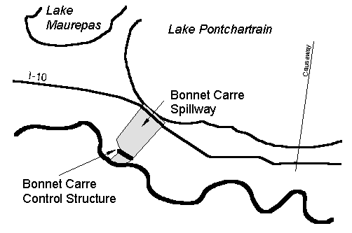
Figure 4: The Bonnet Carre Spillway allows flow from the Mississippi River to bypass New Orleans through Lake Pontchartrain.
3 Old River Control Structure
3.1 History
The story of Old River is that of a conflict between the Red River and the Mississippi, where the Mississippi won the battle but nearly lost the war.
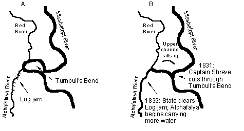
In the 15th century A.D., the Mississippi captured the Red River. A meander loop of the Mississippi, Turnbull Bend, grew west to where it intersected the Red. The Mississippi also intersected a distributary channel, the ancestral Atchafalaya (Fig. 5). Captain Henry Shreve, founder of Shreveport, was a steamboatman on a mission, that of shortening the trip upriver. In 1831, he cut through Turnbull Bend at Shreve's Cutoff. The cutoff meander became known as Old River. Flow through Old River slowed, and the upper portion silted up. Flow down the Atchafalaya was partially blocked by a thirty-mile long log jam. In 1839, the State of Louisiana began clearing the log jam. The flow down the Atchafalaya began increasing. Water began flowing in the reverse direction on the lower portion of Old River, going from the Mississippi down the Atchafalaya, a much shorter path to the Gulf, 142 miles rather than 315.
Scientists and engineers began to recognize that the Mississippi might change course completely, a disaster for the commercial corridor from Baton Rouge to New Orleans. In 1953, a special commission recommended that the flow into the Atchafalaya be controlled by large engineering structures at Old River. It was authorized by Congress in 1954 and completed by 1962 at a cost of $67 million.
The first part of the project was the closing of the lower portion of Old River with an earthen dam. A navigation lock was constructed just south and parallel to it. A channel was dug above the upper portion of Old River and the Low Sill structure was completed to control the flow through the channel. In addition, the Overbank Structure was built to allow flow during the highest floods.
3.2 The 1973 Flood and Present Conditions
High floods were not long in coming. In 1973, the Mississippi River had one of the highest floods of the century. The Low Sill Structure was opened wide, but was nearly overwhelmed. Part of the Structure collapsed. In drilling exploratory holes to determine the damage beneath the Structure, the Corps of Engineers drilled in the stilling basin behind the gates. They found water. The Structure had been nearly undermined. It was held in place mainly by the deep steel pilings.
The construction of the Auxiliary Structure was begun in 1981 and completed in 1986 at a cost of $206 million (Fig. 6). The Auxiliary Structure allows the closure of the Low Sill Structure for maintenance. At nearly the same time, a hydroelectric power plant was constructed to take advantage of the water level difference between the Mississippi and Atchafalaya. It is capable of generating 192 megawatts of electricity.
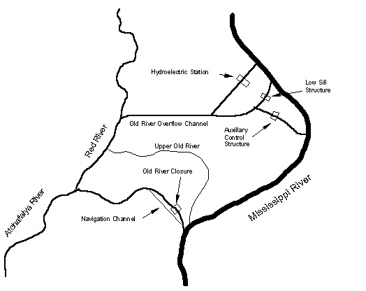
Figure 6: The present configuration at Old River.
3.3 The Future
The Corps of Engineers believes it now has the flow at Old River well under control. Whether the Mississippi will find another place to alter its course is another story.
4 References
The following references were drawn upon extensively for preparing this guide:
- Martin, Angel, and C.D. Whiteman, 1989. Geohydrology and Regional Ground-Water Flow of the Coastal Lowlands Aquifer System in Parts of Louisiana, Mississippi, and Florida---A Preliminary Analysis. U.S.G.S. Water Resources Investigations Report 88-4100.
- McPhee, John, 1989. The Control of Nature. New York, Farrar Strauss Giroux.
- Snowden, J.O, W.C. Ward, and J.R.J. Sudlick, 1980. Geology of Greater New Orleans: Its Relationship to Land Subsidence and Flooding. New Orleans Geological Society.
- Spearing, Darwin, 1995. Roadside Geology of Louisiana. Missoula, Mountain Press Publishing Company.
- Ward, K.A., 1982. Ecology of Bayou St. John. Master's Thesis, University of New Orleans.
- Widmer, M.L., 1993. New Orleans in the Twenties. Gretna, Pelican Publishing Company.
File translated from TEX by T TH, version 2.72.
On 6 Sep 2000, 09:33.